Monday, November 25, 2013

11-24-13 Black Diamond Mines

On a Sunday morning, we got a call from our son, Chris, asking if we wanted to go with him and our two grandsons, Elisjsha (age 10) and Zachery (age 8), to Black Diamond Mines. It sounded fun, so Maureen and I went along. Luckily, Chris has a minivan with plenty of room so we all rode together, including his wife, Jonnie and our granddaughter, Makaila (age 3), who we dropped off in Concord to spend the afternoon with a friend.

When we got to the park, we found out that Chris picked today to come because they were having open house in the mines. As a park district employee he keeps up with events like this. At the Hazel-Atlas mine entrance, they handed everyone a hard hat and a flashlight. Neither seemed necessary, since there were no low ceilings and it was all well-lit. We followed the tunnel deep into the mountain, mostly through sandstone, and it was interesting to see the tilted layers, and in places ripple marks where the sandstone had been deposited beneath the sea. there were holes where we could see into huge chambers that had been hollowed out by mining.

in the mine
Coal mines were started here soon after the gold rush, and it was a busy place for much of the last half of the 19th century with 5 towns and thousands of miners, many of whom were recruited from mining areas of England and Wales. Then, from the 20's through the 40's, mining was resumed for sandstone for making glass. That was the part of the mine that we were exploring. We only went about a quarter mile, but they said that there were over 200 miles of tunnels in the area.

on the trail

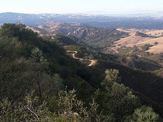
Back out of the mine, we continued on the trail up a steep little ravine. At the first trail junction, Maureen and Elisjsha decided to head back down on the trail to the right that led down another little ravine. Chris, Zachery, and I went on up to the top of the ridge and turned left, climbing another quarter mile or so to a hilltop with a great view to the valleys and ridges to the southeast.

Zachery and Chris at the top of the hill

I enjoy hiking with kids, but it takes a lot of patience and flexibility. I thought the boys would be really interested in the mine and the rocky trail, and maybe they were, but didn't show it much. They seemed much more interested in stopping for a snack along the way. The trail is quite steep, and both boys complained about how hard it was and "how much farther do we have to go?", but then a minute later were running ahead up the trail. On the way down, Zachery was running down a steep gravely place, right after his dad had told him not to run, and of course, he slipped and fell. It probably hurt, but no real damage was done.

Back at the bottom of the hill, we met up again with Maureen and Elisjsha, found a table and ate some lunch, then headed back to the car. The boys found a couple of sticks which became light-sabers, and fought a little battle up and down the mounds of tailings on the way. It all added up to a nice afternoon and we all had fun.
View east from Sommersville site

about 1.5 miles, 500 ft. climb


Tuesday, November 12, 2013

11-8-13 Anthony Chabot

A Friday afternoon and Maureen and Cherry were going riding, and I felt like a hike. For the last couple of months I've had a pain in my left heel and it has gotten worse lately. But it wasn't too bad that day and I didn't think it would give me any problems. On a couple of my hikes I've explored some of the northern end of Anthony Chabot Regional Park, going out from Bort Meadow on the Grass Valley Trail and Ranch Trail. Both times I had turned left at the Goldenrod Trail and made a loop, but I had never turned to the right. I wasn't sure how this would work, because the map shows the Goldenrod Trail deadending without connecting with any other trail or road. I figured we could find some way to get from there to the Parkridge Drive park entrance.

So Darby and I started off from the Bort Meadow Staging Area on the now familiar trail past the meadow and then steeply up the hillside to the west. Turning right onto the Goldenrod Trail at the top, we found it much the same as to the left. A young guy on a mountain bike passed us and asked if we knew where the trail ended. I had to tell him I didn't know either. Soon we came to a gate with a road on the other side. The biker went out through it, but the trail continued so we kept following it. The trail ended at another gate, and through it was what appeared to be an equestrian facility, but it was deserted -- no people or horses. A couple of the structures looked quite new, and signs said that they had been funded by the 2008 bond issue. It looked like it could be a nice place to keep a horse, and it was surprising that it was unused. At the far end of the facility, past an interesting old Spanish-style building, we came to a gate with a sign "Private Property", and a driveway beyond it. I looked at my iPhone and saw that we were only 100 yards or so from Skyline Blvd. So we walked down the driveway and found the street. This part of Skyline is a divided road with a trail along the center divider, so we didn't have to worry about the traffic.

At Parkridge Dr. we turned right and walked several blocks on sidewalks to the end of the street and the park entrance. A few yards from there, we turned right on the Macdonald Trail which gradually descended along the eastern ridge back to our starting point. It seems that this section of the Bay Area Ridge Trail is a popular trail with mountain bikers, and several of them passed us going dangerously fast. I noticed a sign for the Brittleleaf Trail heading down the east side of the ridge. I don't know what Brittleleaf is or why anyone would want to go down this .39 mile, steep dead end trail, but maybe one of these days I will check it out.

Coming down the last hill, my heel was hurting quite a lot now, and I was glad to be near the end of the hike. It probably wasn't a good idea to hike with a sore foot because the next day I could barely walk on it. Now, after a couple of days rest, it is not so bad, but I need to take it easy for a while.

Back home, I looked up Oakland City Stables, and found out that it was in use as recently as last year and that it was the site of a popular program to let city kids learn about riding and working with horses. It has an interesting history going back to the 1820's and the Peralta family, the original landowners of most of the East Bay. Apparently, the city closed it because they couldn't find a suitable manager for it and didn't want to provide any funding to keep it open.

4.6 mi. 900 ft. climb


Sunday, November 3, 2013

11-3-13 Wall Point - Mt. Diablo

View west from Wall Point
It was a nice Saturday afternoon and I wanted to go hiking. I've been avoiding hiking with Darby on weekends because there are usually lots more people out with loose dogs. If I left him home there would be no problem and besides I could go anywhere, including trails where dogs are not allowed. So I decided to go Mt. Diablo State Park. Years ago I had done a loop from the Macedo Ranch entrance that I remembered being one of my favorites, so I set out to do it again.

When I arrived at the end of Green Valley Road, I found that it required a self-service parking fee. I needed $5.00 (with senior discount), but I only had 3. I wasn't going to give up my hike for a couple of bucks, so I put what I had in the envelope and hoped that I would get away with it. I figured that it would cost them way more than $2 to track me down and give me a ticket. We'll see what happens.

I started off up over the first hill and down into Pine Canyon. Everything is very dry now, but still quite pretty in the late-season afternoon light. There was quite a lot of fall colors (at least a lot for California) along the way, especially the maples and sycamores. At the bottom of the canyon, I turned right, heading upstream and climbing gradually along the dry creek bed. After a mile or so, the road climbs more steeply and keeps climbing for a good long way. As it begins to head away from the creek, I turned right on the Secret Trail, a single-track trail that is not exactly secret since it is well-signed. It climbs some more, then cuts across the side of the ridge to the south and connects with the Wall Point Road. I turned right again and began returning along the ridge. Now it was apparent that I had gained a lot of elevation and there were lots of great views of the Blackhawk and Danville areas. The ridge, part of the Black Hills, is covered with chaparral with lots of big sandstone outcrops -- very scenic. Soon a little climbing brought me to a high point and I began to wonder where exactly was "Wall Point". Looking at the map later I found that it was at that high point. From there, the road goes up and down along the ridge, but mostly down, until the loop is done, and there is only the last small hill to cross.

Sometimes these days I remember hikes from long ago as not being too hard, but that was when I was young and in good shape. When I try them again I find them much harder than I remembered. That didn't happen so much today. I ended up tired, but not completely worn out, and it was an enjoyable afternoon.

6.2 miles, 1300 ft. climb


Sunday, August 25, 2013

8-23-13 Anthony Chabot

Ranch Trail
I felt like doing a little hiking this morning, but didn't feel like I had the energy for anything very long. Plus, I wanted to have time to do some painting later. I remembered that I had intended to go back to the Ranch Trail in Anthony Chabot so I could get a good GPS track on it, since the park district map shows it obviously in the wrong location. Fog hung over the hills and kept it cool all morning and nice for hiking.

Darby and I started off from the Bort Meadow Staging Area and headed up the valley on the Grass Valley Trail. Not far beyond the Bort Meadow group camp area, the trail crosses the creek and switchbacks steeply up a spur ridge as the Ranch Trail. We came across a guy with a couple of dogs who leashed them and passed by without incident. Near the top of the ridge, we turned left on the Goldenrod Trail and went about a half mile, then turned left on the Buckeye Trail. It descends steeply down log steps into a little canyon. We passed the guy with the two dogs again -- apparently he was doing this loop in the opposite direction. Otherwise, we met no one else on the trail.

We were back at the car after just an hour of hiking. This is a nice little loop for a relatively short hike. It's a bit of a workout, with some steep climbing, and it is a pretty area with lots of variety in the vegetation -- grassy hills, brush, shady woods. The map below, while still not perfect because my GPS track was somewhat erratic, shows the locations of the trails much more accurately than the park map, which as you can see, is way off.

2.4 miles, 500 ft. climb


Sunday, August 18, 2013

8-13-13 Sierra Camping

Maureen and I and Darby just spent 8 days in the Sierra. We spent 5 nights car camping and two nights in a cabin. It was a very relaxing trip and I got a good dose of Sierra -- something that I never seem to get enough of. We're calling this our vacation, but I don't know if you can still call a trip a vacation after you are retired.

We started off at our all-time favorite campground, Sherwin Creek near Mammoth Lakes. We've been camping there for about thirty years, ever since a friend recommended it. It's about three miles southeast of town on a partly unpaved road. It looks like it is just out in the sagebrush, but then you come to the campground in beautiful pine forest and aspens. The place is lightly used and quiet because most campers head for the lakes. We've noticed that every campground seems to have its own personality because of the type of campers that are attracted. This one seems to attract more of our kind of people -- those who are content to just quietly hang out and enjoy their surroundings. It's also conveniently located just a couple of miles from the many stores and restaurants of Mammoth Lakes.

Our Sherwin Creek campsite
Near Sherwin Creek Campground

Our first day, we did just that -- enjoyed our surroundings with a couple of short walks around the area around the campground. It's an area right on the edge of where the mountains meet the desert, a mix of sagebrush, forest and riparian vegetation that I find especially beautiful. Our next day, we set out to hike to Sherwin Lakes, a two mile hike with about 800 ft. of climbing. Maureen likes to hike, but she is not especially goal-oriented, so she turned back about a half mile from the lakes. Darby and I continued and I enjoyed sitting by a nice little lake and he enjoyed swimming after a thrown stick. Later, we drove out to Hot Creek and walked around a little. It is still fenced off and closed to swimming, but several people had climbed the fence and gone in anyway. It is still a beautiful spot even without the soak in the hot springs.

Sherwin Lakes

Hot Creek
We packed up and headed north, stopping as usual at the Mono Lake Committee store in Lee Vining. We had wanted to break up our trip so we wouldn't be in the same place too long, so we had reserved a campsite at Twin Lakes near Bridgeport. We were familiar with the area, but not the Lower Twin Lakes Campground, and when we got there, we discovered that our campsite was not designed for tent camping. The campsites were all packed together side by side with just a driveway for an RV and a table. No space for a tent. Plus, there was a group right next to us with a loose dog running around that was sure to make trouble for Darby. We seemed to be stuck in a bad situation -- no useable campsite on a Saturday afternoon in an area where all campgrounds are usually full in August. We wanted to check for available reservations in other campgrounds, but we had no phone service, so we drove back into Bridgeport, stopping along the way to check out all the other forest service campgrounds nearby. No luck with any of that, so as a last resort, I called Mono Village, the private resort at the head of the lakes, and they said they had sites available. We've stayed there several times before, and Maureen doesn't like it, but we didn't have much choice. But we found a nice site by the creek with plenty of room, and we settled in. The resort is a funky old place that has barely changed at all since I was first there in the late 50's. It's one of those places where families have been coming to for several generations.

 
Meadow next to Mono Village Campground

We walked around a nearby meadow that was really beautiful in the late afternoon light with the high peaks all around. The next day, after a little excitement when a small bear walked through our camp, we hiked up the Horse Creek Trail. I had been up and down Horse Creek several times in the past, and I remembered some nice views. We came to the cascades after about a half mile, and Maureen decided that it was far enough for her, and turned back. Darby and I continued up another mile or so and about 900 ft. up, to the first little flat valley, and were rewarded by a great view of Matterhorn Peak above a waterfall.

Matterhorn Peak from Horse Creek

Monday, we packed up again and drove north, stopping in Minden for groceries, and then to Ebetts Pass. I remembered years ago hiking a short distance to a little lake, but we couldn't find the trail, so we just sat on a hillside with views all around and ate some lunch. We continued to Lake Alpine and checked in to the Lake Alpine Lodge in a rustic little one-bedroom cabin. It was a nice change to have a clean place with a real bed and bathroom.

Lake Alpine Lodge cabin

Tuesday, we decided to hike to the top of the hill on the far side of the lake, a place called Inspiration Point (I wonder how many other places have that same name?). After a steep climb of about 700 ft., we were at the top of the ridge with interesting cliffs and outcrops of volcanic rock. I took a look at my phone and saw a happy birthday message from my old friend, Rosemary and her husband, Bo. I also got one from another friend, Norma. Yes, it was my birthday, and I couldn't have asked for a better one. Nice little hike, a swim in the lake in the afternoon, and a good steak for dinner at the lodge restaurant.

Maureen and Darby in Lake Alpine

We had been wondering about the lodge since Maureen checked Yelp after we had already made our reservations, and the reviews of both the cabins and the restaurant weren't so good. One of the burners on the stove didn't work and some folks that we met said they didn't have any hot water, but otherwise I guess we were lucky. I think maybe some people expect a mountain cabin to be like an urban hotel, but we expect it to be a bit old and funky. Makes it seem like roughing it some.

Altogether, a very good trip. I would have liked to have more time for some longer hikes, but it's also nice to just relax in beautiful surroundings.

Thursday, August 1, 2013

8-1-13 Dinosaur Ridge


Yesterday, I was adding some maps to some of my previous posts, and I noticed that there was a comment on my post about Dinosaur Ridge from 4-19-13. I was quite surprised. Since I haven't done anything to publicize this blog, I didn't think anyone would ever find it. The comment suggested an easier way to get to Dinosaur Ridge from Bellhurst Lane at the top of the Columbia development off Cull Canyon Road. I had been intending to try this anyway, so I decided to go ahead and do it this morning.

Part of this route would be on EBMUD land, where dogs are not allowed, so I left Darby at home. Lately, I've noticed him limping a bit after some of our longer hikes, so I'll probably start leaving him behind more in the future. He's going on 8 now, not so young anymore, and he's getting some arthritis. I'll really miss his company on hikes.

The entrance to this trail is a driveway and gate between two houses, and it is not at all obvious from the street. On the gate, there is a sign saying "No Trail Access". But there is a gap between the gate and the fence just big enough to squeeze through. Obviously the park district wants to discourage anyone from using this entrance, but I doubt that they would do anything to enforce it. Anyway, on a Thursday morning, there was no one around, so I was able to slip past the gate unnoticed. Just inside a second gate there were three horses in a pasture who appeared unconcerned by me walking by.

Soon the houses were out of sight and I was following a grassy and brushy ridge with nice views of the hills all around. After a half-mile or so, there was another gate entering EBMUD land. The sign said that unlike all of the other EBMUD trails, no permit was required for this one. The trail continues as a wide fire road going up and down near the top of the ridge, and then climbs a couple hundred feet to the top of Dinosaur Ridge. Since I had been there only a few months ago, I didn't bother staying long, but I did notice that where before it had all been green grass and poppies, now it was all dead grass and weeds.

On the way back I passed another hiker doing the same hike as I, the only other person I saw all morning. It was a nice little hike -- quiet, good views, and it only took a little less than 2 hours. It was definitely an easier way to get to Dinosaur Ridge, although it was still a bit of a workout.

The map below shows my route deviating from the trail shown on the EBRPD map. That's not because I went off the trail, it's because their map is not accurate. I've recently noticed inaccurate trail alignments on several park district maps, and in this case I checked it against the GPS track on my iPhone, and my red line is closer to the location of the real trail.

4.2 miles, 800 ft. climb.


Sunday, July 28, 2013

7-26-13 Las Trampas

 It looked like another good day for a hike -- morning fog promising to keep the heat down. After dropping off my grandson, Zachery, at Camp Tenderfoot, Darby and I drove to Danville. I wanted to check out an entrance to Las Trampas Regional Wilderness that I hadn't been to before, the Ringtail Cat Staging Area at the end of Hemme Ave. This appeared to be a good starting point for a loop through the northern end of the Park.

This area around Las Trampas Peak has always been special to me because it was one of the first wild areas that I knew as a kid. In the mid-50s, When I was about 10, my dad got the idea that we could hike over the hills from our home in Lafayette to my aunt and uncle's home in Danville. Dad and I and my younger sister set out without any directions or maps and somehow found our way there. At that time the whole area was undeveloped private land, but we rarely encountered anyone. If we did, the ranchers didn't mind too much as long as we didn't bother the cattle. We made many more hikes like that, and found a nice route along the northern end of Las Trampas Ridge to Las Trampas Peak, and then down the present Madrone Trail into San Ramon Valley. I wanted to revisit part of that route today.

Climbing Ringtail Cat Trail

The fog had cleared but it was still a bit cool as Darby and I started off following a dry creekbed from the small parking lot. Soon, the trail began a steep climb up the hill to the left. After a good hard climb, we came to a junction with the Madrone Trail in a open grassy flat overlooking the valley. I remembered this as the site of an oil drilling rig that was once here in the late 50s. They must not have found any oil, because it didn't stay there long. My plan was to head up the Corduroy Hills Trail to Eagle Peak, but right at this junction I saw a fairly well worn path heading straight up the hill. I figured that if it kept on going that way it would intersect my intended route, so I gave it a try. It turned to be a pretty good trail, but a steep climb. We continued on the Corduroy Hills Trail up the steep-sided crest of a ridge to Eagle Peak, coming out of the woods to steep chaparral and sandstone outcrops. Several years ago, I was hiking here, stepping between these rocks, when suddenly there was a big rattlesnake coiled and rattling in the middle of the trail. Somehow I managed a mid-stride leap and missed the snake. He was as startled as I was and slithered into the rocks before I could aim my camera.

Eagle Peak

 A steep, slippery scramble down across a saddle brought us to the Las Trampas Ridge Trail and we turned right. Now on a more familiar trail, we followed the ridge northwest to Las Trampas Peak. The actual peak is up a short side trail, but I had visited it fairly recently, we didn't bother going to the top. We descended a long grassy ridge to the northeast, then curved back into the canyon on the Madrone Trail. By now it was a bit warm, and I knew that Darby was getting pretty dry. On our park map there was a "horse water" symbol on the trail, and we found it as a small, muddy pond in the main canyon. After drinking for about 5 minutes without a break, Darby was now feeling better. We climbed a bit and contoured along the south side of the canyon shaded by oaks and bay trees. We finally completed our loop, and headed down the Ringtail Cat Trail back to our car.

Eagle Peak from near Las Trampas Peak

I hadn't bothered to estimate how long a hike this would be, but I knew it would he a pretty challenging one. It turned out to be just about the same distance and elevation gain as the hike I did on Mt. Diablo last week. I thought it was well worth the hard work, a good place to cover a lot of beautiful, rugged country.

7.2 miles, 2000 ft. climb