 |
| Ranch Trail |
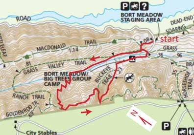
Darby and I started off from the Bort Meadow Staging Area and headed up the valley on the Grass Valley Trail. Not far beyond the Bort Meadow group camp area, the trail crosses the creek and switchbacks steeply up a spur ridge as the Ranch Trail. We came across a guy with a couple of dogs who leashed them and passed by without incident. Near the top of the ridge, we turned left on the Goldenrod Trail and went about a half mile, then turned left on the Buckeye Trail. It descends steeply down log steps into a little canyon. We passed the guy with the two dogs again -- apparently he was doing this loop in the opposite direction. Otherwise, we met no one else on the trail.
We were back at the car after just an hour of hiking. This is a nice little loop for a relatively short hike. It's a bit of a workout, with some steep climbing, and it is a pretty area with lots of variety in the vegetation -- grassy hills, brush, shady woods. The map below, while still not perfect because my GPS track was somewhat erratic, shows the locations of the trails much more accurately than the park map, which as you can see, is way off.
2.4 miles, 500 ft. climb

No comments:
Post a Comment