Tuesday, September 27, 2016

Henry Coe SP 9-24-16

Monument Trail
We were spending a weekend in Morgan Hill where Maureen was participating in a horsemanship clinic with Chris Ellsworth. This clinic was all about working with cattle, and Chris is an expert, having grown up on a ranch in Wyoming. I went along to trailer a couple of horses, help out, and maybe pick up a little knowledge by watching. I find his clinics very interesting, but two full days would be more than enough, so I wanted to do some hiking too. The forecast was for increasing temperatures through the weekend, so I chose Saturday morning to hike. Henry Coe State Park is nearby, and I hadn't been there in about 30 years, so decided to check it out again. In the meantime, the park has grown a great deal, and it is the largest state park in northern California, with many square miles of wilderness. As an old guy with a sore knee, I had no hope of exploring it all. I just wanted a little taste.

I dropped Maureen off at the arena, and drove up East Dunne Ave. to the park headquarters. The road doesn't appear to have had any improvements in the last 30 years, and it felt pretty narrow and winding in my big Chevy pickup. I managed to get into a parking space in a small lot with lots of young backpackers with their gear spread all over, and went to the visitor center and asked for a recommendation for a short hike. A very nice woman ranger suggested a loop to Frog Lake and back, which appealed to me since it take me back through some of the same area I had seen years ago. These high ridges are the only place in the bay area that I know of where Ponderosa Pines grow, which makes this area rather unique.

Ponderosa Pines

My route took me on a trail up a steep hill and into the pines. It felt a bit more like the Sierra foothills than the Coast Ranges. Then there was a long downhill on a fire road. At the bottom, a sign said it was only .2 miles to Frog Lake, but I skipped that and turned right on the Flat Frog Trail. I wondered what was meant by a flat frog, but I soon got that it was the trail that was flat. The single-track winds along the hillside with hardly any change in elevation. That made it easy walking, and I was more able to relax and enjoy my surroundings. After a couple of miles, the trail came to the Manzanita Point Road. I thought I was done, but it was still another .6 miles on the Corral Trail back to the park headquarters.

View southeast from Flat Frog Trail

Even at my slow pace, it only took about 2 hours to make the loop, and I still had plenty of time to drive back down, pick up some sandwiches, and have lunch back at the horsemanship clinic. It turned out to be a very enjoyable hike. It's one I would do often if it weren't such a long drive from Hayward.

4.5 miles, 700 ft. climb

Thursday, July 21, 2016

The Preserve Trail

Now and then I look around online to see what other hikers are doing. One of my favorite sites for that is that of Bob Burd (www.snwburd.com). I've always liked being on top of a hill, but Bob carries this to a very obsessive extreme. He is the ultimate peak-bagger, spending as much time as possible climbing anything he can find. On his site, he writes interesting reports of every climb with lots of good photos. It probably contains way more information about hiking anywhere in California and the west than is available anywhere else, but to use it as an information resource may take a lot of digging. I'm always curious about blank areas on the map and his reports often satisfy that curiosity and provide a little armchair adventure.

One of his recent reports was a climb of the high point of Main Ridge, in Pleasanton Ridge Regional Park. I've been interested in this northern part of the park which I've never visited because it much too long a hike for me from the park entrance on Foothill Road. Bob chose to try a shorter approach from the northeast, which would probably mean crossing either private land or EBRPD land bank closed to the public. He didn't know which it would be but breaking rules doesn't seem to bother him much. In looking for a good starting point he happened on a staging area and small trail system near Stoneridge Mall that neither he nor I were aware of. The Preserve Staging Area is run by the city of Pleasanton, and provides a nice place to get a little exercise out in the hills.


 On a nice Thursday, I took Darby along for a drive to Pleasanton to pick up a prescription at Kaiser. When that was taken care of, I realized that the staging area was only about a block away, so why not go check it out. I hadn't really planned on doing any hiking, but there was the trail, so why not see where it led? We did a gradual climb along a grassy hillside with nice views all around. We could hear some kids playing in the creek below. Then a steeper climb and a loop around below several houses, and heading down again. Some ups and downs across a couple of ravines, and finally across the main creek at the bottom. As we did the short climb back to the staging area, we passed a couple of teenage girls leading a group of small kids. I was pleased to hear the girls explaining to the kids why they shouldn't be cutting switchbacks.

I hadn't been expecting much since the area looks pretty small on the map and it is so close to lots of development, but I was pleasantly surprised. It was a very nice little hike and I'll probably be back again sometime when I have an extra hour or so for a walk.

1.4 miles, 275 ft. climb


Friday, May 27, 2016

Vargas Plateau 5-25-16

I recently saw the news of a new regional park opening, Vargas Plateau. The park district has owned this land for 20 years, but just opened it to the public this month (May 2016). I don't know why it took so long for them to add a small parking lot and toilets, but it's great that they have finally done it because this is a beautiful area.

I had some free time on a Wednesday afternoon, so Darby and I drove down Mission Blvd. to 680 and then off on Vargas Road, a narrow lane winding through the hills. There were only two other cars parked in the lot and no one around. It was probably a good choice to go on a weekday, because when I mentioned it later to my son, Chris, who works for the park district, he said that he had heard that the lot has been filling up on weekends.

We started off on the Golden Eagle Trail gently climbing along a hillside with nice views of Fremont and the bay. At the top we turned right on the Upper Ranch Trail into a wide, flat valley with views of the hills to the east. Soon we began descending to the north approaching the rim of Niles Canyon. The views into the canyon were quite impressive. When you are driving through it, you don't fully realize how deep it is. After a short stretch through shady woods along the steep canyon wall, we climbed back up along grassy hillsides to complete a loop.


I noticed what at first looked like a small herd of cattle on a little hill across the valley, but when I looked more carefully, I could see that they were buffalo. I don't know who is raising them, but it was quite a surprise to see them here in the bay area.

This was really a very enjoyable hike. The trail is an easy one with mostly gentle slopes, and the area is pretty. There is a lot more peace and quiet and open spaces that you would expect so near the busy 680 freeway and the city of Fremont.

3.6 miles, 470 ft. climb


Friday, May 20, 2016

map design

Ever since I can remember I have had an obsession with maps. I can spend hours studying maps, imagining the places that they represent. I still have boxes of old maps that I have collected. I'm not interested in their value as collectibles, I just want to be able to look at them. I've spent countless hours drawing maps, experimenting with different ways of showing topography and trying to make them more beautiful. I feel that there is a strong connection between my love of the natural world around me and my love of its representation by lines and shapes on paper. So, even though this is a blog about hiking trails, this post is going to be all about maps.

I remember when I was about 10, I was pretty excited when my dad told me that he was going buy some maps that showed the hills around our home in Lafayette. When he came home with several topographic maps, I was at first a bit disappointed. What were all of these brown squiggly lines? But I learned how to read the contours, and soon I could see the shapes that they represented. I began using the maps while hiking in the hills and finally appreciated how useful they could be. I spent many hours drawing my own maps, learning to show topography with shading or hachures, and I became pretty good at it. Then, in my mid-twenties, I decided to get more serious about it and make something really challenging.

My idea was that I would make a 3D map of Yosemite and paint it with natural colors, and I imagined it as more a work of art than a map. I based it on a 1:125,000 topographic map of the park — about 30 in. square. I spent a year or so of my spare time building it. I encountered plenty of problems to overcome, but when it was done, I was quite pleased with the results, and I still enjoy looking at it hanging on my bedroom wall.

Relief map of Yosemite, cast in epoxy and hand-painted

In the early 70s, when I was making the map, lots of people were looking for more satisfying ways to make a living and I was one of them. I thought maybe the map would lead to something — maybe I could sell copies of it, but then I got another idea, writing a trail guide to the East Bay. That project turned to be relatively successful. My book East Bay Trails needed a lot of maps and to make them required a lot of learning about graphics and printing, and that eventually led to a career in graphics. A year or two after I had finished my book, I was approached by a young guy, Tom Taber, who wanted help with a similar book that he was writing about the Santa Cruz Mountains. We went on a lot of hikes together, and I produced all of the maps for his first edition.

Quite a few years later, I was browsing the library shelves at Cal State Hayward, and I came across a book that really blew my mind. It was Kartographische Gelandedarstellung by Eduard Imhof, a Swiss cartographer. It was all about methods of showing topography on maps, going way beyond anything I had seen at the time. The only problem was it was all in German, but I was able to understand some of it from the illustrations. Some time later an English translation appeared, Cartographic Relief Presentation, and I was able to read it. Imhof's ideas were used to produce all of the Swiss topographic maps, and in 1995, I was in London and was able to visit a map store that sold them, and I picked up several. In addition to contours, these maps included beautiful drawing of rocks and cliffs. I wanted to be able to design maps like that.
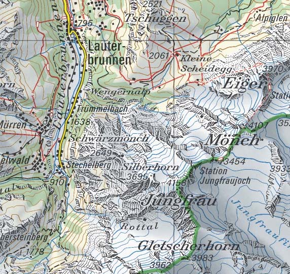

example of Swiss topo map
I'm a long-time member of the Sierra Club, and sometime in the early 90s I came across a note in the Yodeler, the newsletter of the San Francisco Bay Chapter. The editor, Don Foreman, was looking for volunteers to produce maps to illustrate articles. I had recently bought a Macintosh and was learning to use Adobe Illustrator and Photoshop, so I began producing maps for the newsletter, and continued to do so for about 20 years. At first it was a struggle to work with the software (which was still in its earliest stages), but I soon figured it out. Often the biggest challenge was to get good directions about what kind of map they wanted. The author of the article did not always agree with the editor on what to include in a map. But overall, it was a fun experience and I enjoyed seeing my maps in print.
typical example of my maps for the Yodeler
In the early days of the internet, there were not a lot of map resources available online, but by the mid-90s, I realized that some useful stuff was showing up. I learned about GIS software and wanted to explore it but it was nearly all for Windows, not Mac. I found one Mac program, Avenza's MapPublisher, and it allowed me to convert USGS map data files into Adobe Illustrator. The map quadrangles showed up as just a tangle of lines, and it took many hours of manual work to sort them out and make something resembling a map.

The idea came to me to put together a complete map of the Bay Area and color it with the shading and natural color ideas that I had been dreaming of for years. It soon became a massive project that I became obsessed with for many years. It ended up taking about 15 years on and off because I kept discovering new and better resources on the internet, so I actually reworked much of the map several times. I still see it as a work in progress, but I'm pretty well satisfied with it now.

complete map

full scale section

Before I retired, I was able to use some 3D software, mostly Strata Studio Pro, and it occurred to me that the software could be used to make a 3D model from a map. I spent quite a lot of time figuring out how I could do that, and actually put together a model of a small local area that combined topography with satellite images, and it worked. Soon after that Google Earth appeared, doing much the same thing but covering the whole world. It felt like my efforts had been kind of a waste of time.

I had another experience kind of like that when I came across closedcontour.com. A guy created a topographic map of the High Sierra which in many ways is an improvement over the USGS version, and he says he did it in three weeks by writing code to bring together several online databases. His method was way more efficient than my efforts with Photoshop and Illustrator and it made me realize that the future of mapping is with programmers, not artists. But that's not going to stop me from playing around with map design. The internet is loaded with ugly computer generated maps. A little artistic sensibility can go a long way.

When I started this blog, I thought I was going to create my own beautiful maps to illustrate my hikes, and I even started working on some of them, but I soon realized that it would mean countless hours of work. I decided that copying parts of EBRPD maps was a much easier way to go.

When I started writing this blog post, I began taking another look at Swiss topo maps, and got the idea that maybe I could apply a similar style to the High Sierra. So I've spent the last several months trying to do that. It took quite a few false starts before I worked out a way to do the rock drawing. I chose an area of the northeast corner of Yosemite National Park, partly because it is an area I am quite familiar with, but also because I felt that it is a good example of High Sierra terrain. I put it all together from USGS topo maps and satellite images available online. It was slow, tedious work, but I enjoyed doing it.

complete map area

section of map at full scale
When I finished this map, I thought it would be fun to do Yosemite Valley in the same style, so I set off on another project. This time it went together much faster because of my experience with the first map.

section of map at full scale

Monday, November 30, 2015

Mt. Diablo 11-29-15

It was a Sunday and a good day for a hike. I don't like to do weekend hikes with Darby because there are usually lots of dogs on the trails, so since I wasn't taking him, I decided to go to Mount Diablo (where dogs are not allowed on trails). The recent cold weather had made my knee hurt more than usual, so I didn't want to do anything very difficult. I thought I would try the Madrone Canyon Trail, a mile-long section that would be new to me. It doesn't appear to be a new trail, but it doesn't show up on my old map from 1987.

I had seen a recent news story about problems with bicycles on the mountain. Apparently there have been a lot of collisions between cars and bikes in recent years. The state park addressed the problem by putting up signs saying "do not pass bikes on blind curves". That sounds reasonable, but I doubted that the problem could be solved simply by putting up signs. On my drive up, I saw first-hand how serious the problem was. Most of the road is a narrow two-lanes with no shoulders cut into a steep mountain slope, and many blind curves. It is a steep climb, so the uphill bikes are barely moving. Several times, I had to come to nearly a complete stop and wait what seemed like several minutes for the bicyclists to round a corner. I would guess that a lot of drivers don't have that much patience. There needs to be a better solution, but I don't know what that would be.

I paid my $10 at the gate and parked at Curry Point. I started off heading up the Summit Trail, then went left on the Staircase Trail. It was a chilly day, but clear and sunny, and it felt good to be outdoors again. Soon I was down in the chaparral and sandstone of the Rock City area. It is a bit confusing with lots of side trails through the rocks, but there were plenty of trail signs showing the way. The signs told me that I was on the "Trail Through Time", and I enjoyed reading several large signs explaining the geologic features. This is one of the most popular areas of the park, and there were lots of families with kids climbing on the rocks. Watching them, I remembered doing the same myself some 60 years ago, and then more recently with my sons and now my grandkids.

Rock City


The "Trail Through Time" signs led across the main road and down into a canyon on the Madrone Canyon Trail. It was a pretty walk shaded by oaks and a few madrones with lots of moss and ferns. At the bottom, a bridge crossed the dry creekbed and I turned left on the Devils Slide Trail. It climbed up a little side canyon, passing Sulfur Spring, a puddle of milky water with a bit of sulfurous odor. The woods gave way to grassy hillsides at the top and I turned left again on the Knobcone Point Road. A bit more climbing brought me back to my car.

Madrone Canyon Trail


This turned out to be quite a nice little hike, and not hard enough to bother my knee very much. On the map, the Madrone Canyon Trail appears to parallel the main road, but in reality it is far enough down in the canyon that I was totally unaware of the road being nearby.

3.3 miles, 750 ft. climb


Wednesday, November 18, 2015

Diablo Foothills 11-17-15

It has been a couple of days since the last rainstorm, and the weather has been cold and clear. Yesterday I did a little hike at Garin and an icy wind made it a bit uncomfortable. Today promised to be warmer with less wind, so another hike seemed to be a good idea. I was thinking of somewhere around Mt. Diablo, and looking at the map, I noticed a trail to the top of Castle Rock, one that I had never tried. I could go up Pine Creek, take the Sunset Trail to the top of the ridge, and follow it back to Castle Rock. The only problem was that the map shows the trail ending at the park boundary just past the top of the hill. I figured that it is only about a half mile back down to the trail along the creek, and I should be able to manage that even if I did have to cross a bit of private property. I would leave Darby at home since part of my hike would be within the state park, but he could use a rest day anyway.

Shell Ridge Trail
 On the drive out there, I thought maybe I could extend my hike a bit by starting at the Old Borges Ranch instead of the Castle Rock Trailhead. But then I missed the turn and ended up at Castle Rock anyway. I still could check out a bit of the hills to the southwest, so I started off up the Diablo Scenic Trail. The name sounded good, and I found that it lived up to its name. With some green grass starting to show after the recent rains, the wooded hills were quite beautiful. Then there was a very steep section up a chaparral covered hill that slowed me down a bit. At the top, a single-track trail branched to the left, avoiding a bit more climbing, so I tried it. It turned out to be a shortcut to the Shell Ridge Loop Trail, which I intended to take anyway, so it all worked out. Soon I was back down to the Stage Road Trail along Pine Creek.

Rocks above Stage Road Trail
I continued along the familiar trail up the creek. We have had three pretty good rainstorms in the past month, but because of the drought, there still was no water in the creek. I've noticed the same with several other creeks. I think the land has become so dry after years of drought that it just soaks up the rainwater and doesn't allow any to run off. It was a very pretty walk anyway, with groves of oaks and green grass coming up all around.

Sunset Trail
I turned left on the Sunset Trail, a rough single-track climbing steeply up a rocky little ravine. At one of the steepest parts, I heard something and looked up to see a mountain biker speeding toward me just a few feet away. I quickly stepped up the steep bank to get out of the way as he sped past. Then I lost my balance a bit and fell back to the trail, just missing his back tire. I doubt that he noticed, but if I had fallen back a split second sooner I would have knocked him off the trail for a bad fall. I think mountain bikes are great, but it's too bad that a few riders have no regard for other people's safety let alone their own.

At the top of the ridge, I turned left on a fire road that soon turned into another single-track, the Castle Rock Trail. This turned out to be the best part of my hike. The trail winds along the top of this sharp ridge, partly in oak woodland, partly in chaparral, with lots of big sandstone rocks. It reminded me of the trail along Las Trampas Ridge. At several spots there are great views of the tops of the spectacular rocks rising from the southwest side of the ridge. At one point I heard voices below, probably from climbers on the rocks. Fortunately I had chosen the fall season to do this hike because the area is closed much of the rest of the year to protect the peregrine falcons that nest in the rocks.

Castle Rock Trail
I reached what appeared to be a high point on the ridge, the hill named Castle Rock on the map, and then the trail became harder to follow. I stayed to the right at each fork and that turned out to be the right way. I came out on a grassy hillside with a fence signed "Park Boundary". But it didn't say "no trespassing" so I crawled under the fence because the way looked much easier on the other side. I followed cow trails or deer trails down the hillside, and they soon became more obvious trails from human use. At one point the trail went straight down a very steep slope and I had considerable difficulty getting down without falling. After that it wasn't so bad and I ended up at the mouth of a little canyon. I had to crawl under another fence and then I was back on the Stage Road Trail. Right at that spot, there was a sign reading "Habitat Enhancement… No Entry Beyond This Point". I regret breaking the rules, but I doubt that my footsteps caused that much damage. Another half mile and I was back to the car.

So once again I have to say that this report is just a recounting of what I did and not a recommendation that others do the same. I don't want to be responsible for anyone getting into trouble for breaking the rules or hiking on private property. On the other hand, I have some pretty strong opinions about property rights. I don't see the harm in someone walking across private land that is far from any homes or other development. When I visited England years ago, I enjoyed walking across farmer's fields on paths that had been used for centuries. We could do that here with some more reasonable attitudes.

This hike turned out to be one of my best in a long while. I like places with a lot of variety and this one had plenty -- rolling grassland, oak woodlands, shady streamsides, rocky chaparral, and great views.

5.5 miles, 1200 ft. climb


Tuesday, October 20, 2015

Del Valle 10-19-15


It was a beautiful fall day and I felt like getting outdoors for a while, but not for a long hike. It seems that lately my hikes have been getting shorter and easier, but I haven't yet given up on longer ones. While thinking about places to go I remembered that several years ago when I checked out the regional parks Trail Challenge, one of the trails listed was at the north end of Del Valle, an area I had never seen. We have been horse camping several times at Del Valle in past years, and have ridden on some of the trails, but always at the south end of the lake where most of the facilities are -- marina, swimming areas, campgrounds. At the north end, there is not so much going on. There is Camp Arroyo, a youth camp used by the YMCA and the Taylor Family Foundation, there is the dam, which is a restricted area, and there is a trail leading south to the reservoir.

Darby and I drove out there at mid-day, passing Sycamore Grove park, the Veterans Hospital, and Wente Winery to the Arroyo Road Staging Area. The trail passes through an old walnut orchard, crosses the creek, and begins climbing the hill rather steeply. Soon views open to the north of Wente's vineyards and golf course and the valley beyond. The steep grade doesn't let up until you reach the top of the hill, and there before you is a great view of the lake. I had expected to get a good view of the dam, but it is hidden behind a hill in a restricted area. I could see the East Shore Trail descending along the treeless hills, looping around Heron Bay, and the Heron Bay Trail heading down closer to the shore. I had thought about making a loop using those trails which would add a couple more miles, but now that I could see the trails, they didn't look that interesting. We just turned around and headed back down the hill.

We were on the trail only a little over an hour, but climbing the hill had given us plenty of exercise and we enjoyed the views.

2.0 miles, 500 ft. climb